Image use policy
Our images can be used under a CC BY attribution licence (unless stated otherwise).
TIMBER
Unique ID: MAS-D100177
Object type certainty: Possibly
Workflow
status: Published ![]()
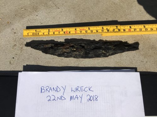
Section of highly degraded timber measuring approximately 216 mm in length by 31 mm at its widest point. The ends taper to a point, in a regular fashion that seems a deliberate aspect of the timber rather than part of the process of degredation. At least five nail or bolt holes are apparent in the face of the timber, further differentiating the piece from a section of unworked natural wood. The function of the timber is unidentifiable from the data available. As it has been recovered from a wreck it is likely to relate to the vessel itself and can tentatively be interpreted as a ships timber that has been exposed for at least part of its life on the sea bed.
Notes:
This find comes from an unidentified wreck known as the Brandy Wreck, situated east of Portland Harbour in Weymouth Bay, Dorset. An investigation of the newly discovered wreck was carried out by Wessex Archaeology (2016) in conjunction with The Shipwreck Project, a local organisation who discovered the site, and at the behest of Historic England. The lack of datable evidence from secure contexts, structural elements of a vessel and other factors meant that a precise date or name of the vessel could not be determined. Broadly, the vessel is thought to date between 1600 and 1825 AD and may relate to a naval or merchant vessel, or potentially be a chance accumulation of artefacts. Vessel currently has no NRHE or HER designation numbers.
This item was found with a swivel gun (MAS-D100180), length of braided copper (MAS-D100183) and a flat strip of copper (MAS-D100184).
Class:
TRANSPORT
Sub class: SHIP
Wreck details
Droit number: 091/18
Chronology
Broad period: POST MEDIEVAL
Period from: POST MEDIEVAL
Period to: NINETEENTH CENTURY
Dimensions and weight
Quantity: 1
Length: 220 mm
Width: 35 mm
Discovery dates
Date(s) of discovery: Tuesday 22nd May 2018
Personal details
Found by: This information is restricted for your login.
Recorded by: P T
Other reference numbers
Droit ID: 091/18
Materials and construction
Spatial coordinates
4 Figure: SY7375
Four figure Latitude: 50.57411317
Four figure longitude: -2.38265074
1:25K map: SY7375
1:10K map: SY75SW
Display four figure position on What3Words
Unmasked grid reference accurate to a 1 metre square.
References cited
- Wessex Archaeology, 2016. Brandy Wreck Weymouth Archaeological Services in Relation to Marine Protection Undesignated Site Assessment. Salisbury : Wessex Archaeology, ,
Similar objects

Find number: MAS-D100183
Object type: UNIDENTIFIED OBJECT
Broadperiod: POST MEDIEVAL
Find comprises of a single length of copper or copper alloy wire, measuring approximately 140 mm long and 10 mm in thickness. The wire consist…
Workflow: Published![]()

Find number: MAS-D100184
Object type: UNIDENTIFIED OBJECT
Broadperiod: POST MEDIEVAL
A single piece of copper alloy sheeting, measuring approximately 70 mm by 55 mm with a thickness of c. 2 mm. The item bears 4 grooves pressed …
Workflow: Published![]()

Find number: MAS-D100233
Object type: UNIDENTIFIED OBJECT
Broadperiod: NINETEENTH CENTURY
This find appears to be some form of decorative finial manufactured from a non-ferrous metal, possibly a copper alloy. It measures approximate…
Workflow: Published![]()


