
Database search results
Back to simple search | Back to advanced search
- Discovery: Coastal walking
- Show this many records per page: 10
- Page: 2
- Sort: broadperiod
You searched for:
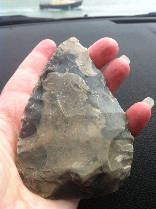
Record ID: MAS-O100203
Object type: HANDAXE
Broad period: PALAEOLITHIC
County: City of Portsmouth
Workflow stage: Published ![]()
Images of this find were sent to Andrew Shaw, flint specialist at Wessex Archaeology who determined that this object is an ovate biface handaxe that is in mint condition. This example is approximately 50-60 mm in width and 80-100 mm in long-axis. He said that the form of the butt and lateral margins are reminiscent of late Middle Palaeolithic handaxes, and it's possible that deposits of that age may be found in the intertidal and offshore zone in. Based on the images alone, he said that it's possibly a late Middle Palaeolithic handaxe dating from between 60,000 to 30,000 years ago. Han…
Created on: Friday 3rd August 2018
Last updated: Tuesday 31st March 2020
Spatial data recorded.
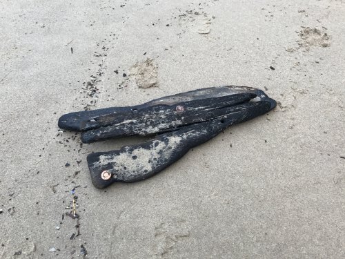
Record ID: MAS-O100026
Object type: SHIPS TIMBER
Broad period: NINETEENTH CENTURY
County: North Yorkshire
Workflow stage: Published ![]()
Two fragments of waterlogged wood with two copper fasteners dating from the post-medieval period onwards.
The wood may be the remains of two planks of wood used in the construction of a ship as the planks are secured with one copper fastening and a hole is visible where another fastening may have also been used. Copper rivets are the standard method of fastening the planks to each other in clinker constructed vessels, or in the planks to the ribs or frames (Traditional Maritime Skills website, accessed September 2017). Clinker is a method of constructing the hull of a boat by fixing w…
Created on: Saturday 28th January 2017
Last updated: Tuesday 22nd May 2018
Spatial data recorded.
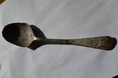
Record ID: MAS-100007
Object type: SPOON
Broad period: MODERN
County: Devon
Workflow stage: Published ![]()
This spoon is made of a metal alloy, possibly copper alloy, and was probably originally plated. Its manufacture would have been cast. The Royal Australian Air Force (RAAF) crest is stamped into the end of the spoon. The crest features the RAAF monogram with a laurel wreath surmounted by a crown. This crest is the same style as that used for cap badges and is modelled from a Royal Air Force (RAF) crest.
The more widely adopted RAAF crest was commissioned and designed in 1937 and accepted in 1939. It is composed of the imperial crown mounted on a circle featuring the words 'Royal Austra…
Created on: Thursday 8th September 2016
Last updated: Wednesday 14th December 2016
Spatial data recorded.
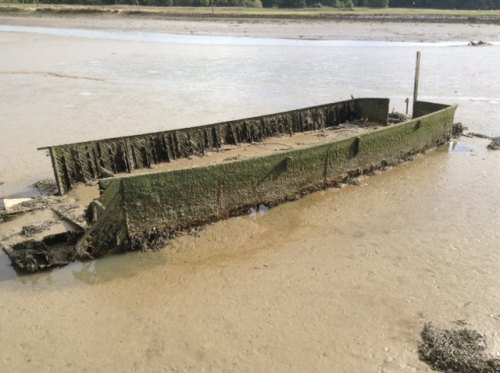
Record ID: MAS-100012
Object type: LANDING CRAFT INFANTRY
Broad period: MODERN
County: Suffolk
Workflow stage: Published ![]()
This hulk is situated on the River Deben, just outside of Melton (Suffolk) and is estimated to measure 11.5 m in length and 3 m in width. The structure is rectangular in shape with squared edges and straight sides. One end suggests the presence of a bulkhead and a hatch or doorway, while the other end is missing. Parts of possible rudder components are located close to the bulkhead, suggesting that this is the stern. Internal frames can be seen throughout the remaining structure; estimated measurements reveal a spacing of approximately 0.42 m. The hull is constructed of wood in a doubl…
Created on: Friday 30th September 2016
Last updated: Monday 10th October 2016
Spatial data recorded.
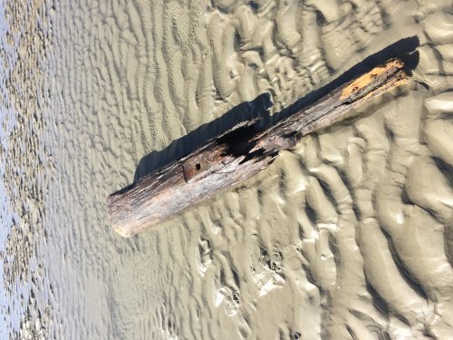
Record ID: MAS-O100031
Object type: TIMBER
Broad period: MODERN
County: Hampshire
Workflow stage: Published ![]()
Possible ships timber or part of other marine or land based structure. Truncated rounded timber with hole and evidence of mounting plate for furniture, broken or rotted off at one end exposing heart wood and a knot in the wood. Approximately 2000 mm long and 600 mm in diameter. The undamaged half of the timber appears in good condition, implying a more recent date for the timber, whereas the other part appears to have suffered extensive degradation. The arrangement of damage to the timber suggests it may have been partially submerged during its useful life, possibly as part of a shore …
Created on: Thursday 9th March 2017
Last updated: Friday 21st February 2020
Spatial data recorded.
Records per page: 10 20 40 100
Sort your search by:
Which direction?
Total results available: 15
Search server index: asgard
You are viewing records: 11 - 15.
Search statistics
- Total quantity: 49
- Mean quantity: 3.267
- Maximum: 17
Filter your search
Object type
All Object type optionsCounty of origin
Broad period
Institution
Material
Workflow
11 - 15 of 15 records.
About us
About our site

Data labs
Find us
Wessex Archaeology
Portway House, Old Sarum Park
Salisbury SP4 6EB
T: +44(0) 1722 326867
E: